Solving Navigation and Asset Tracking Challenges in Remote Australia — in partnership with Hema Maps
Last Updated on September 16, 2025
by White Widget Team
Offline. On track. No compromises.
When Hema Maps—Australia’s authority on off-road navigation—asked White Widget to help build a navigation and asset-tracking app for one of the world’s largest corporations in their sector, we knew it would push mapping and mobility tech to its limits. Thousands of kilometres of private tracks, minimal cellular signal, and strict safety requirements. The result? A battle-tested Android navigation application that keeps field crews on course and assets accounted for, no matter how remote, for one of the world’s largest robot train networks.
Partnering with Australia’s remote‑navigation experts
Hema Maps is famous for its richly detailed, highly accurate maps of Australia’s most signal‑starved regions. Their GPS datasets are the go‑to reference for 4×4 adventurers, campers, and national agencies alike. They came to White Widget because:
- Proven transport pedigree. From Angkas and Grab to custom GIS platforms, our team has shipped dozens of geo‑enabled products at a national scale.
- Lean, senior engineering bench. We bring native Android specialists who understand mapping SDKs inside‑out—Google Maps, HERE, Pelias, Mapbox, ArcGIS, and of course, the ability to work with Hema’s own tiles.
- Delivery under pressure. Tight timelines don’t scare us; they focus us.
What made this application different?
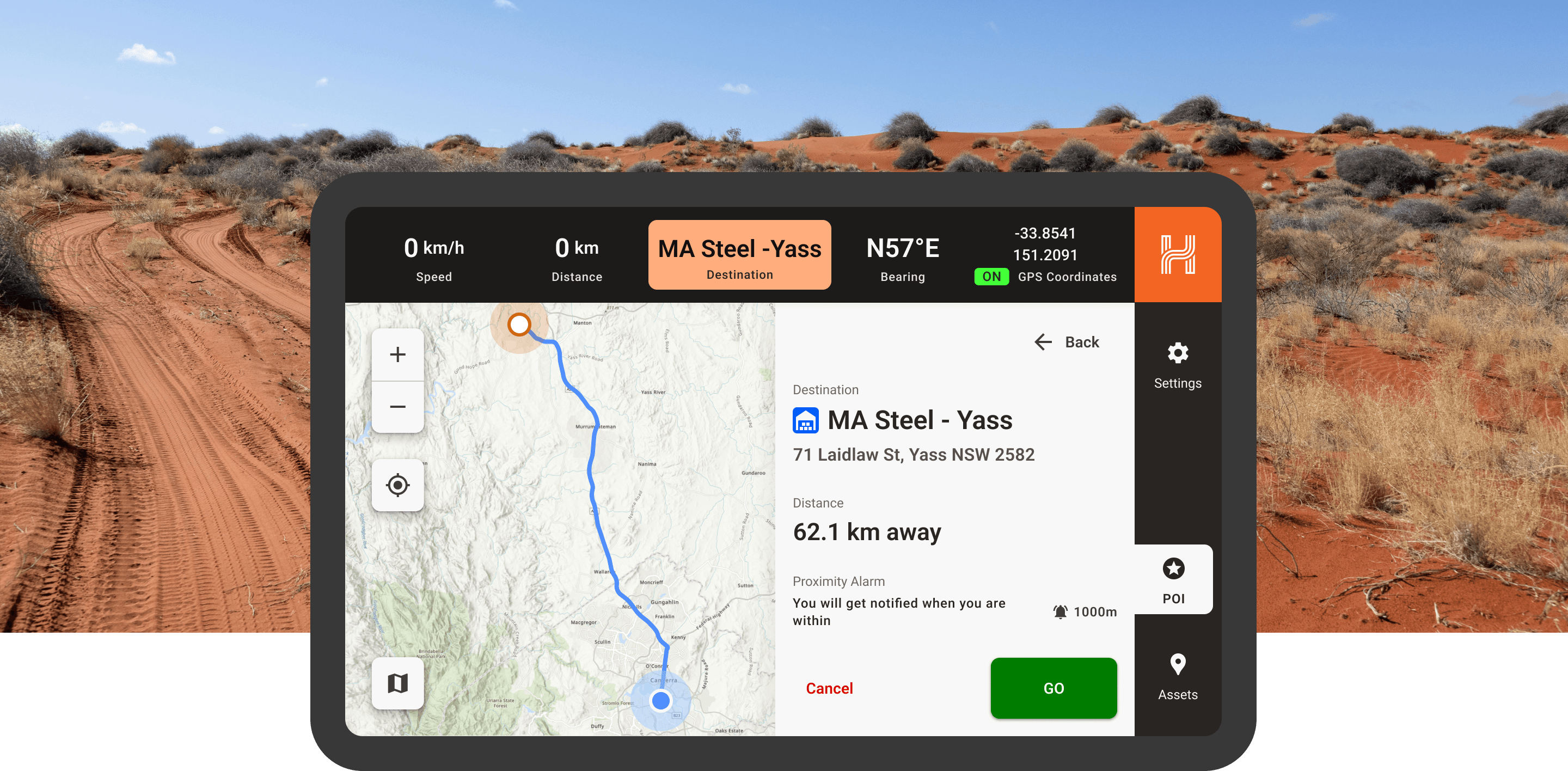
The brief was deceptively simple: “Plot our private tracks, display asset locations, and alert drivers when they approach points of interest.” In reality, that meant:
- Offline‑first cartography. Tile caching and vector‑based rendering so the map stays fluid in the outback.
- Secure domain data. We limited the client’s proprietary track and asset layers so it could only be accessed within the app.
- Zero‑guess UX (both visual and sound design). Big‑button waypoint navigation, one‑tap map styles, and audio and visual cues that work despite the rumbling of the vehicle.
- No thinking required. Accidental presses, missteps, and not looking at the screen were all factored into the design for an app that needed to be a critical safety tool for its users.
Safety was at the core of every design decision. Since the app is used by maintenance crews in Australia, we prioritized ergonomics and visibility.
Touch targets were intentionally placed on the right side of the screen for easier reach during right-hand driving and sized generously to accommodate larger fingers.
The color system was designed with high contrast to ensure visibility even under harsh sunlight, maintaining legibility on in-vehicle devices.
We also implemented proactive sound alerts that notify drivers well before reaching their destination. The audio cues are intentionally disruptive—just enough to break through ambient noise and prompt attention without overwhelming the user.
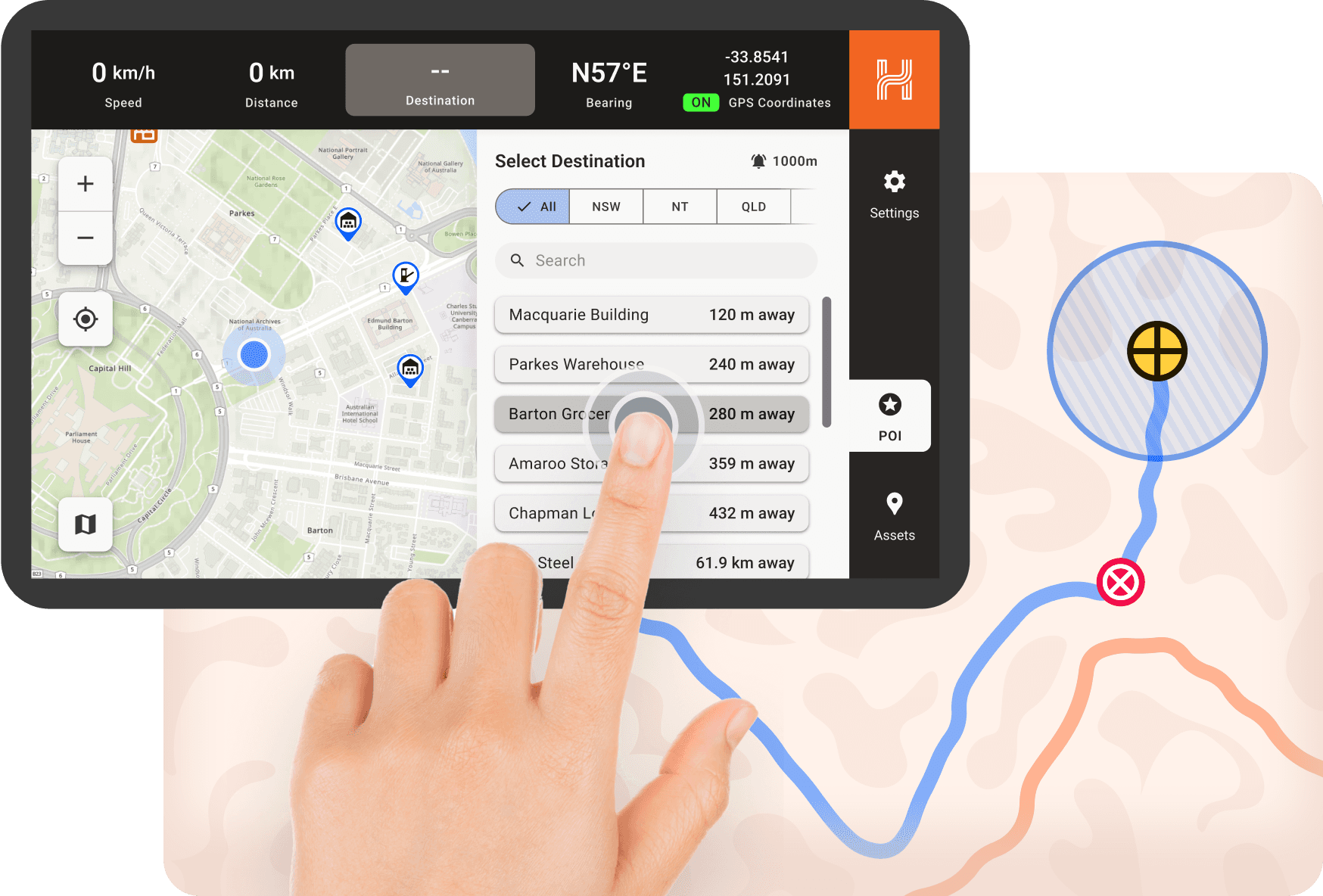
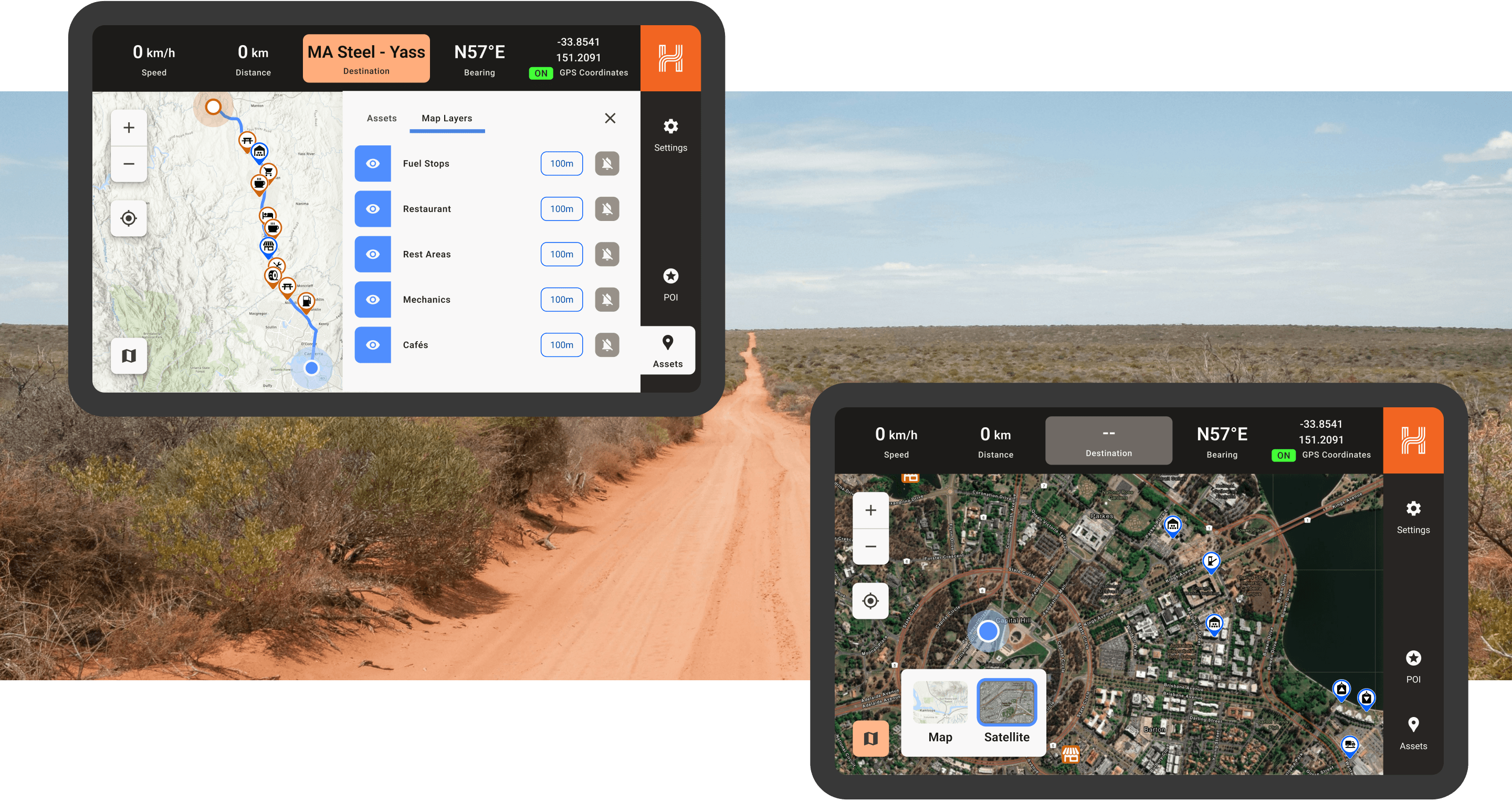
Key features of the navigation & tracking system
- Real‑time navigation & dynamic re-routing — OTA (over the air) map downloads proceed smoothly when there’s signal, and there’s fallback if the user is offline.
- Switchable map layers — terrain, satellite, and custom thematic overlays (e.g. asset health, maintenance zones, and dozens of types of assets in their own distinct colours)
- Contextual POIs & geofenced alerts — configurable thresholds trigger haptic, audio, or visual cues for safety‑critical events.
- Precision re-routing — gone off-course? No problem. The app allows the user to pick a different route, which triggers route recalculation.
The Hema mapping solution is a flexible foundation for multiple industries
Hema and White Widget really enjoyed making this platform a reality for the customer. What’s really fascinating is that Hema’s solution also translates directly to supporting these industries:
Table
Hema Mapping Solutions for Multiple Industries
| Industry | How it could be used |
|---|---|
| Utilities & Energy | Inspect powerlines or pipelines across vast territories |
| Agriculture & AgriTech | Monitor crops, sensors, and autonomous equipment |
| Logistics & Regional Transport | Optimise last‑mile delivery in rural corridors |
| Forestry & Land Management | Track crews and machinery in dense bushland |
| Emergency & Disaster Response | Offline routing for SES and rural fire units |
| Government & Public Works | Maintain roads, parks, and water assets far from HQ |
| Tourism & Outdoor Ops | Guide guests safely through multi‑day trail systems |
Ready to future‑proof your field operations?
Hema Maps continues to set the gold standard for Australian navigation. Explore their products at hemamaps.com. If you need a custom navigation and tracking application like this one, especially for the rugged Australian outback, please reach out to Hema for a demo, they’re the only team capable of mapping regions where other teams don’t dare to travel. (Please tell them you found Hema through this article.)
If you’re wrestling with navigation, specialised mobile apps in general, or ruggedised mobile workflows, White Widget can help. We design, build, and scale digital products that thrive where connectivity doesn’t.
Let’s talk about turning your operational challenges into a competitive advantage.
About the Authors
White Widget Team is known for delivering holistic, award-winning software solutions across diverse sectors such as transport, healthcare, and media, emphasizing a comprehensive approach to digital innovation, since the company was founded in 2012.